At the end of 2013, we decided to travel to see the famous Galapagos Island in Ecuador and the Machu Picchu ruins in Peru. We selected Go Ahead Tours. We had already done a tour to Australia and New Zealand with them in 2011, and we were pleased with the experience. The trip to Ecuador and Peru was going to be at the beginning of 2014, a 16-day trip.
During this trip, as in many others, I carried a Scripture, or a Scripture based reflection. This time this was my focus: “You need the Word and wisdom to help you steer, discernment to help you brake, self-control to stay on your line, the helmet of salvation, the Holy Spirit to tell you when to lean left or right, fellowship with other believers, and every other blessing God offers to get you moving, protect you from harm, and enable you to master the course. All these parts balance together to create an exciting ride. It is fun, much safer, and not nearly as lonely. That is the kind of faith I want, and that is the kind you can have, too.” From Randy Robinson, (LIFE Today and LIFE Today 2019)
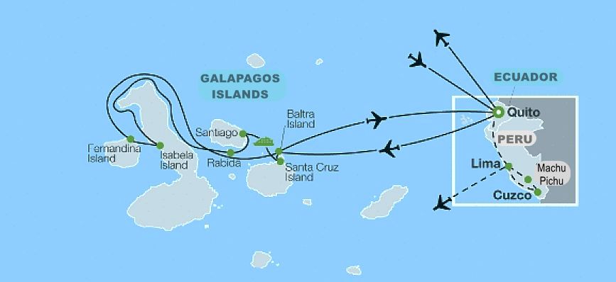
On February 14, 2014, we flew on Delta to Quito, Ecuador. Of course, we had to stop in Atlanta first. A Go Ahead representative met us in Quito and took us to our hotel, the Alameda Hotel Mercure.
Ecuador is a South American country of fifteen million people, located on the equator. It is bordered by Colombia, Peru, and the Pacific Ocean. There are sixty-four volcanoes in continental Ecuador. Of these, seven are active and forty-eight dormant. In the Galapagos, there are fourteen more. Of these, ten are known to be active.
Ecuador is divided in four regions: Coast which is the most fertile region. Sierra, or highlands where Quito is located and contains most of Ecuador’s volcanoes and all its snow-capped peaks. Oriente, or Amazon region with the huge Amazon national parks and indigenous rainforest zones, which are vast stretches of land set aside for the Amazon indigenous tribes to continue their traditional way of living. And Insular or the Galapagos Islands.
In Quito, early in the morning on February 15, our group departed on a guided sightseeing tour of the old city, passing the Tumbaco Valley. We saw the Legislative Palace, the Independence Square and El Sagrario Church. We first visited the Basílica del Voto Nacional which is a large neo-Gothic church considered the largest of its kind in the Americas. It was initiated in 1883 and is known for its unique design featuring animal gargoyles representing Ecuadorian tortoises, iguanas, condors, monkeys, jaguars, ant eaters.
Then we visited the Plaza de la Independencia or Independence Square. It is surrounded by the Government Palace, the Cathedral of Quito, and the Archbishop’s Palace. In the middle is the Monument to Independence Heroes. Here we visited the Church the Jesuits own la Compañía de Jesus. The altar in this church is made of gold.
Streets are very narrow in the Old Quito as in all colonial cities.
After this visit to Old Quito, our tour headed out on an excursion to the Equatorial Monument at La Mitad del Mundo or Middle of the World, where you can stand with one foot on either side of the equator. The monument is ninety feet tall. It was constructed between 1979 and 1982 to replace an older monument built by the government of Ecuador. It is made of iron and concrete and covered with cut and polished andesite stone. The monument was built to commemorate the first Geodesic Mission of the French Academy of Sciences in the year 1736. Everywhere you see the numbers 00.00.00 Indicating the latitude where you are. The whole area had changed since I had been there before for work. This time it was paved and very well kept. The original location was determined in 1936 by Luis Tufiño, an Ecuadorian geographer who built the first monument in the Middle of the World. More than 40 years later, in 1979, the monument was relocated seven kilometers west of its origin. In fact, the true position of the equator line passes 245-meters north of where they built the major monument.
That night at dinner we were officially introduced to all the members of the group.
Next day we went to Otavalo. On the way we saw many European style houses. The guide explained that before 1950 the people from Otavalo paid for their journey to Europe, using money collected by the community to make themselves known. They sold their textiles and handicrafts and played their music; then they sent money to Ecuador for their families to build houses like they saw in Europe. They built the houses, but the interior is only one spacious room where the whole family lives because they only had send pictures of the exteriors.
Otavalo is an hour and a half from Quito and is 8,441 ft. above sea level. The Otavalo indigenous people are believed to be descendants of the pre-Columbian Cara culture and the semi-mythical Quitu culture. Before the Inca Empire’s expansion in the late 15th century, the region was home to several small chiefdoms.
The main attraction in Otavalo is the indigenous community that still wears their traditional costumes, and the market. The market’s name is la Plaza de los Ponchos. There are ninety permanent stalls, and it was designed in 1970. During the market’s peak, almost one third of the town is full of stalls selling textiles, tagua nut, jewelry, musical instruments, dream catchers, leather goods, fake shrunken heads, indigenous costumes, hand-painted platters and trays, purses, clothing, spices, raw foods, and spools of wool.
Traditional dress for the Otavalo women consists of a long dark skirt with pale underskirt, fastened with a woven belt, and an embroidered white blouse with full, lacy sleeves. The women also wear a cloth binding around their hair. The size and number of strands in the woman’s necklace indicates her relative wealth. When the shawl is worn over both shoulders it means that the woman is married. If only over one shoulder, she is single.
Men in Otavalo traditionally wear a white shirt, calf-length white trousers, a dark blue poncho or jacket and white espadrilles (alpargatas), most wear a white felt hat and style their hair in a single braid at the back as a mark of identity and pride.
On our way back from Otavalo we stopped for lunch at a colonial hacienda called Hosteria Pinsaqui with three centuries of history. Built in 1790. There we also visited the room where the liberator General Simon Bolivar stayed when he was at that Hacienda. Simon Bolivar led what are currently the countries of Colombia, Venezuela, Ecuador, Peru, Panama, and Bolivia to independence from the Spanish Empire.
We also stopped at Cotacachi, the city of leather to buy hats.
On February 27, we flew in the morning, to Seymor airport at Baltra Island in the Galapagos. The Galapagos Islands are an archipelago of volcanic islands distributed on either side of the Equator in the Pacific Ocean. They are 575 miles west of continental Ecuador. There are ten active volcanoes in the Galapagos. The Galápagos Islands and their surrounding waters form an Ecuadorian province, a national park, and a biological marine reserve. The islands have a population of slightly over 25,000. The islands are famous for their vast number of endemic species and were studied by Charles Darwin during the voyage of the Beagle in 1835.
We were taken on board our cruise. Our Ship was the Galapagos Legend. The MV Galapagos Legend is a German-built cruise ship operated by GO Galapagos-Ecuador. Earlier, this ship was called MV Helgoland, and it served as a hospital ship during the Vietnam War from 1966 to 1971. Our 301 ft. ship contained forty-five cabins which can accommodate one hundred guests. It had a crew of sixty, including seven multilingual guides and a doctor.
Day one in Galapagos: After getting settled in our cabin and enjoying lunch on board, we cruised across the quite narrow channel separating Baltra from Santa Cruz Island. In the channel we saw tortoises, iguanas, fish, pelicans, orange crabs and many other gorgeous wildlife. We made a wet landing in Black Turtle Cove. All travel from the ship was done by pangas, which are inflatable dinghies.
That night we enjoyed visiting with the people on board our ship and we listened to a lecture by the head of the Naturalist Guides, Alejandro. The guides oversaw our excursions. You can only enter the Galapagos National Park if an officially qualified guide accompanies you. University courses are required to become a Naturalist Guide. The courses are given by Galapagos National Park Authority and the Ecuadorian Ministry of Tourism. Only a limited number of candidates are accepted into the program each year.
Day two in Galapagos: Next morning we did an excursion to Sullivan Bay, on Santiago Island. We stayed at a great beach for swimming and saw crabs, many kinds of birds, seals and their pups, and iguanas galore.
In the afternoon we visited the small Rabida Island. We enjoyed more opportunities for wildlife viewing, snorkeling, swimming, and walking. Here we saw our first Blue Footed Bobbie and more seals. The food from the grills on board that night was especially flavorful.
Day three in Galapagos: Next morning we set foot on the black sands of Urbina Bay, in Isabella Island where we had the opportunity to snorkel with the sea turtles that swim just offshore, I was innocently swimming there when something touched my shoulder. I turned and through my goggles I saw the big head of an iguana that wanted to say hello! Fortunately, I did not react abruptly, and the iguana just took a good look at me and kept on her way. Marine iguanas can be more than three feet long. They are unique lizards found only in the Galapagos Islands. They can swim and feed on algae from the ocean. They are the only marine lizard species that are considered vulnerable in the world.
On land we saw a group of the famous Darwin finches that gave him, influenced by Greek humanism, all the wrong ideas about evolution. I believe in adaptation.
In the afternoon, our naturalist guided us on a walking tour near Tagus Cove, in Isabella Island, where we learned about the geological history of the Galapagos and saw the blue footed boobies that nest here. We saw Galapagos Penguins swimming, flightless cormorants, and seals. Our tour of Tagus Cove concluded with a dinghy ride to the ship.
Day four in Galapagos: During the next morning we visited Punta Espinosa on Fernandina Island, where we had a terrible time trying not to fall on the slippery and wet rocks of lava flows that have formed these islands. We saw hundreds of marine iguanas, Sally Lightfoot crabs and the fearless Galapagos hawk.
In the afternoon, a dinghy ride brought us to Vicente Roca Point and the Bolivar Channel. We saw our fist Nazca Booby, some swallow tail gulls, and more Galapagos Penguins, the only living tropical penguin and the second smallest penguin in the world. The chilly waters of the Cromwell Current are well up on the Bolivar Channel and attract dolphins and whales to this narrow strait. Again, we admired the Galapagos Fur Seal, endemic to the islands, the smallest and most terrestrial of all fur seal species, spending only 70 percent of their time in the water. Another amazing bird is the Great Frigatebird. Part of their diet is obtained by robbing other sea birds of their catch. This gives them the name of Pirate birds.
Day five in Galapagos: Before flying back to Quito we were taking Puerto Ayora to Santa Cruz Island and had the opportunity that morning to visit the Manzanillo ranch to observe giant tortoises in their natural habitat. One of our group members asked us to take a picture of her under a giant tortoise shell which is really the skeleton of the animal. It consists of a bony shell that protects its internal organs, along with a unique structure of bones including the carapace (top shell) and plastron (bottom shell).
We also went to explore the Bellavista Lava Tunnels approximately 4.3 miles inland from Puerto Ayora. These are a geological wonder formed by the solidification of lava, creating a series of tunnels that stretch over one mile.
Then we were taken to Seymor airport and flew to Quito. That night we went to a splendid dinner at Rincon La Ronda, a great colonial restaurant, where we heard beautiful Andean music.
The next morning, we headed down the Avenue of the Volcanoes. Named by Alexander von Humboldt, it runs two hundred miles south of Quito between two parallel mountain ranges. It contains seven peaks more than 17,000 feet high. It is part of the Pan-American Highway in Ecuador. The Pan-American Highway runs from Alaska in USA throughout all the pacific coast in Canada, the US and South America and then continues in Chile to Chiloe and/or crosses to Argentina. The name of the Cotopaxi Volcano means Neck of the Moon.
The Cotopaxi National Park is a massive nature reserve. It encompasses an area of 33,393 hectares and extends into the Cotopaxi, Pichincha, and Napo provinces. Here we saw several different birds including Andean Teals and Sandpipers. There are some two hundred plant species in the park, including Valerian Root. Another surprise at this park is the wild horses.
Our lunch was at another beautiful Hacienda own by Carrion family for more than two hundred years. It has beautiful gardens and great food. It is located at the Valley of Los Chilos near Quito.
Then back to Quito for a late evening flight to Lima, Peru.
We flew on LAN Chile Airline from Quito to Lima around 8:00 at night. We were taken straight to our Hotel Jose Antonio in the Miraflores area in Lima.
Peru is bordered in the north by Ecuador and Colombia, in the east by Brazil, in the southeast by Bolivia, in the south by Chile, and in the west by the Pacific Ocean.
It is a democratic republic divided into twenty-five regions. When we were there the President was Ollanta Humala, ex-military, son of a Quechua labor lawyer and founder of the Peruvian Nationalist Party.
The population of Peru was 30.5 million multiethnic, 45% Amerindian, 37% mestizo, 15% white, 2% other. The main languages are: Spanish official language, twenty-eight million speak Quechua (92% of the entire population), three hundred thousand speak Aymara.
Peru is a developing country whose main economic activities include mining, manufacturing, agriculture, and fishing.
Next day we were taken again to the airport to take our LAN flight to Cuzco. We stayed at the Hotel Jose Antonio Cusco.
The Killke culture occupied the Cuzco region from 900 to 1200 AD, prior to the arrival of the Incas in the 13th century. Saqsaywaman, the walled complex outside Cuzco, was built by the Killke culture about 1100 AD.
The administrative, political, and military center of the Inca empire was in Cuzco, Peru. The Incas were the largest empire in pre-Columbian America from 1200s to 1532.
The Inca civilization started in the highlands of Peru in the early 13th century, and the last Inca stronghold was conquered by the Spaniard Francisco Pizarro in 1572. From 1438 to 1533, the Incas used a variety of methods, from conquest to peaceful assimilation, to incorporate a substantial portion of western South America, centered on the Andean Mountain ranges. It included Peru, large parts of modern Ecuador, western and south-central Bolivia, northwest Argentina, north and central Chile, and a small part of southern Colombia, it was comparable to the historical empires of Eurasia.
The official language of the empire was Quechua. The Inca called their empire Tawantinsuyu which can be translated as “The Four Regions” or “The Four United Provinces.”
That afternoon we were sure to drink Coca Tea to help our bodies adapt to Cuzco’s 11,000 ft. above sea level! At dinner we tried some Peruvian delicacies.
Next day we took a remarkably interesting tour of Cuzco. First, we were handed was a Boleto Turistico, a ticket that we had to guard with our life, they told us. This was our entrance ticket to several attractions!
The city was planned by the Incas in the shape of a puma, a sacred animal that represents the earth. Qosqo in Quechua means “Navel of the World.” It was constructed according to a definite plan, and two rivers were channeled around the city. It is still unknown how Cuzco was built, or how its stones were quarried. However, our guides gave us several versions on how smart the Incas were and how they cut and polished the gigantic stones of the forts. In November 1533, Spanish explorers invaded the city.
The streets in Cuzco are narrow and the architecture is striking. We saw the Cathedral of Santo Domingo, located in the Plaza de Armas (Main Square). The cathedral’s construction began in 1559 on the foundations of Kiswarkancha. This was the palace of Viracocha, ruler of the Inca Kingdom of Cuzco around one century before the Spanish conquest. The ruler was named after Viracocha who is the great creator god in the pre-Inca and Inca mythology in the Andes region of South America. The word “Viracocha” means “Sea Foam”. He created the universe, sun, moon, stars, and time.
The location of Viracocha’s palace was chosen for the Cathedral to remove the Inca religion from Cuzco and replace it with Spanish Catholic Christianity. The Spaniards used the Incas as a labor workforce to build the Cathedral. Unfortunately, many churches in Peru were built on top of indigenous ruins so archaeologist have a challenging time doing their job.
In the same complex of the cathedral is the Iglesia de la Sagrada Familia Church of the Sacred Family. Adjacent and joined to the cathedral is the smaller Iglesia del Triunfo, the first Christian church to be built in Cuzco. We also saw the Convento Santa Catalina.
Then we took the road to Saqsaywaman where we encountered women in their traditional dress with llamas; they offered to pose for pictures for a donation.
In this place we realized how important the Boleto Turistico or Tourist Ticket was. Everywhere we visited in Saqsaywaman, we needed to present it to get in. We took hundreds of pictures of the ruins. The construction of this worship place has a broken zig zag line representing the teeth of the puma. It faces the main plaza. We walked on a slope with twenty-five angles and sixty walls. The biggest carved boulder of the first wall weighs about seventy tons and, like all the other rocks, was brought from a quarry three kilometers away. The longest of Saqsaywaman’s walls is over 1,300 feet long and almost 20 ft. tall. Limestone blocks have survived time and earthquakes in their original place, so tightly fit together that it is impossible to slip in even a sheet of paper.
Then we headed to Tambomachay. Ninety-two of the 350 temples surrounding the city of Cuzco were used for worship in the cult of springs and water sources. Tambomachay is one of them. We enjoyed seeing little burros along the beautiful scenery walking around this place.
Tambomachay is located about eight kms north of Cuzco and close to the ruins of Puka Pukara. Tambomachay comes from two Quechua words: Tampu was a kind of accommodation and Machay, meaning cave, referring to the many caves that surround the place used to workship the water. Puka Pukara is one of the later constructions. The stones used to build most of the walls are very irregularly shaped, stacked together in a haphazard manner to create walls that are functional, but lacking very much beauty as far as architecture goes (in contrast to a lot of other sites in the area).
The guide told us the experts think that Puka Pukara was built in a rush since it was a military headquarters needed very quickly because of the Spaniards invasion.
Around the ruins, we could see a great monolith of about six meters high. Some people believe it is a toad or a frog, some say it is part of a bigger sculpture of a puma which was broken by the Spaniards. The temple probably was a ritual place, where sacrifices took place on the altars. It is still unclear whether the Incas made human, as well as llamas, sacrifices.
We continued to Qorikancha.
According to historians, when the Incas conquered the Cuzco valley, the founders of the Inca dynasty, Manko Qhapaq and his family, settled on the site now occupied by the Qorikancha. It seems that Qorikancha already existed and was created by the Killke culture preceding the Incas. Later the main temple of the Inca Empire was constructed here.
The great imperial reformer Inca Pachakuteq rebuilt the shrine and covered it with fabulous riches. We saw reconstructed parts of the temple on the basis found inside the Church that was built over the temple.
Qorikancha was dedicated to the worship of Virakocha, creator of the sun, the most important deity in the Inca’s naturalistic pantheon, The temple complex was a glittering palace straight out of El Dorado legend: Qorikancha means “courtyard of gold” in Quechua.
In addition to hundreds of gold panels lining their walls, there were life-size gold figures, solid-gold altars, and a huge golden sun disc.
After the Spanish conquest in 1532, the Qorikancha temple was given to Juan Pizarro, one of Francisco Pizarro’s brothers. Before his death, Juan Pizarro donated the Qorikancha to the Dominican Order. Founded in 1534, the Convent of Santo Domingo was the first Dominican convent in Peru. The Spanish colonists built the Church of Santo Domingo on the site, demolishing the temple and using its foundations for the cathedral. Construction took more than a century.
This church is one of numerous sites where the Spanish incorporated Inca stonework into the structure of a colonial building. Major earthquakes severely damaged the church, but the Inca stone walls, built out of huge, tightly interlocking blocks of stone, still stand due to their sophisticated stone masonry. The site now also includes the Church and Convent of Santo Domingo and museum.
That night in Cuzco we had a typical dinner and show at a restaurant.
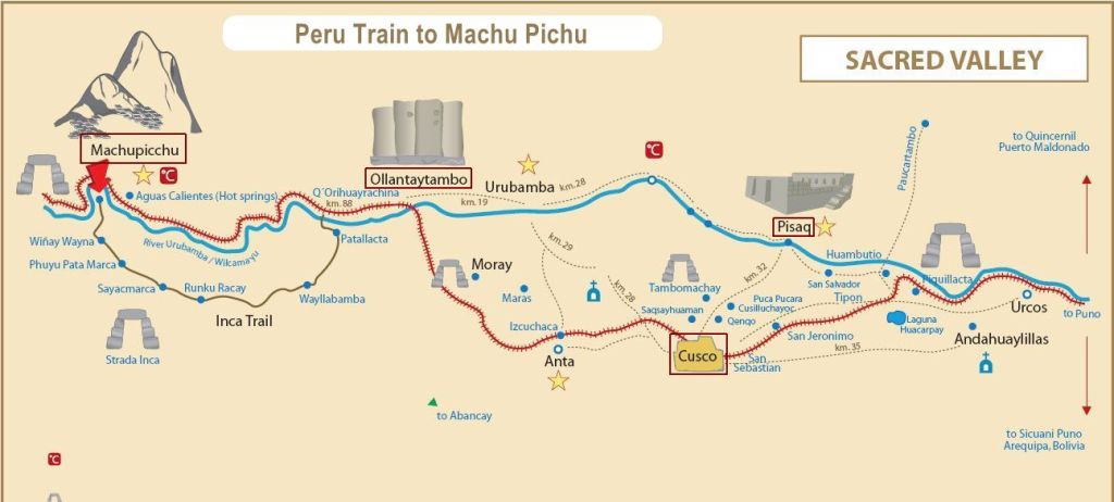
Next day we departed for the Sacred Valley. We were supposed to go to Pisac, but our guide suggested Chinchero, which is well known for textiles, and the group voted to do so. Chinchero was the highest place we visited in Peru at 12,400 feet. We were greeted by very friendly women dressed in the traditional attire of that region. The village is mainly built of adobe mud brick houses. The construction of the wall and many other ruins and agricultural terraces (which are still in use) are attributed to Inca ruler Tupac Yupanqui who used Chinchero as a country resort.
There are beautiful views overlooking the Sacred Valley of the Incas. Chinchero is believed to be the mythical birthplace of the rainbow. The cuys or guinea pigs in this village have a significant role in the villager’s nutrition and they are well taken care of. They raise them in the equivalent of a chicken coop.
Small shrines on top of houses include a cross indicating the family is Christian, ceramic bulls for strength and fertility, a cask of corn beer to tie them to their ancestors, and a vial of holy water to sanctify the house. These we saw during all our traveling by bus.
We visited ‘Balcon del Inka’, a cooperative of families. In this place our guide was Chaska, which means star. She gave us the most delightful demonstration on the whole wool process. They clean the wool with a natural shampoo that they also use to wash their hair. She gave us a detailed demonstration and how they spin and dye the wool. It was hard to believe how those green-looking dried herbs could produce so much color!!! She showed us the various elements used for dying such as plants, minerals, and insects. Chaska also showed us the cochinilla or Cochineal, a parasitic insect that eats the cactus pads (or nopales) and from which the crimson-colored dye carmine is derived. This is after applying lemon to it. Watching the wool changing color was awesome. Fascinating and all done in excellent good humor.
We left with the image of the women weaving and how their children are taught about the importance of their skills and gifts. Their market and display were also open all week. We were fed pork there, not guinea pigs.
From Chinchero we continued to Sacred Valley. This valley fed by numerous rivers contains many archaeological remains and villages. The valley was sacred to the Incas due to its special geographical and climatic qualities.
We stopped at a point that allowed us to see the complete valley facing the city of Urubamba. The valley extends between the towns of Pisac and Ollantaytambo. The Urubamba River, Willkamayu in Quechua, meaning the sacred river, flows through the Valley. This river flows north-north-west for 450 miles.
From there we continued for lunch at Moccopata, west of Urubamba, at the Hacienda Alhambra. This hacienda had beautiful grounds and courtyards, a clay oven, and some stores, of course. Here we were delighted with petting llamas, alpacas, and vicuñas. And a cat called Rayas.
Next, nestled among these beautiful mountains, Ollantaytambo was the most picturesque city we visited. The construction is still quite primitive. On the southern edge of the town, an Inca esplanade with the original entrance rebuilt as a Plaza de Armas, Main Square, was surrounded by colonial and more modern buildings.
Ollantaytambo dates from the late 15th century and has some of the oldest continuously occupied dwellings in South America. The city preserves all the Inca constructions including the irrigation system and traditional Inca construction doors like a building we saw containing a soda fountain.
The local people were easily recognized in their brightly colored hand-woven clothing, orange and red shirts as they go about their daily business.
Standing anywhere in the town we could see the ruins of the original Inca buildings. Ollantaytambo is 9,160 feet above sea level. It was the royal estate of Emperor Pachacuti who conquered the region, built the town and a ceremonial center.
The part of the hill facing the town is occupied by the terraces of Pumatallis, framed on both flanks by rock outcrops. Due to the impressive character of these terraces, the Temple Hill is commonly known as the Fortress; however, the main functions of this site were religious. The main access to the ceremonial center is a series of stairways that climb to the top of the terrace complex.
Also facing the ancient Inca ruins of Ollantaytambo is “Winay Marka” the rock formation that resembles a human face at Cerro Pinkuylluna, a 140-meter-high figure of Wiracochan, the messenger of Viracocha.
At Ollantaytambo we took the train to Aguas Calientes. It took approximately 1 hour and 45 minutes. The journey offered us beautiful views of the Sacred Valley. That night we stayed at the Hotel El Mapi by Inkaterra with contemporary ambience.
We started that day around 6 am. It was raining softly. Around 6:30 we took the bus to the Sanctuary. It took around 40 minutes. We marveled at the numerous curves of the road and the beautiful ethereal effect of the fog on the mountains. We could see the clouds looking down. We encountered a rockslide that made us advance very slowly. However, we arrived well in Machu Picchu ruins. Machu Picchu is at 7,900 ft. above sea level.
When I had been there before, in 1982, it was wild. Lots of llamas wondered about the ruins and the place looked abandoned. This time the authorities were taking much better care of this ancient architectural wonder.
The Incas built Machu Picchu probably around 1450. Its original name is unknown. Machu Picchu means Old Mountain or Old Person Mountain. It was only in 1999 that Peru established a conservation management system for the historic sanctuary.
The layout of Machu Picchu is incredibly unique. The site is located on a steep mountainside in the Andes and is comprised of numerous stone structures and terraces. It was discovered on July 24, 1911 by Hiram Bingham, an American academic. At least, he was the first person to report about this place.
The site is separated into three areas – agricultural, urban, and religious. The structures are arranged so that the function of the buildings matches the form of their surroundings. The agricultural terracing and aqueducts take advantage of the natural slopes; the lower areas contain buildings occupied by farmers and teachers, and the most important religious areas are located at the crest of the hill.
We visited several places starting with the Funerary Rock Hut. Believed to be the place where Incan nobility members were mummified. Then we went to Temple of the Sun, a semi-circular construction built over a strong rock. On the temple of the Sun there is a tower with a trapezoidal window, built over a rock of pure granite. A rock inside the temple could have served as an altar. During the June solstice the rising sun shines directly into one of the temple windows, indicating a perfect alignment between the window, rock, and solstice sun. Beneath the temple lies a cave.
We went down a long set of stone stairs and to the left we found the Royal Tomb. This cave-like area contains ceremonial niches. Next, we visited the quarry. This is where they carved the rocks.
The view from Machu Picchu’s Sacred Plaza (square) makes one appreciate the superb craftsmanship of the Inca. Surrounding the plaza are the most important buildings of the city. The Principal Temple is an example of excellent Inca stonemasonry, with its large stone blocks polished smoothly and joined perfectly. The plaza is enclosed on three sides, open to the west with an alignment of 245 degrees.
We saw then the Temple of the Three Windows that forms the easterly side opening on the plaza facing Llactapata mountain and the distant summits of Nevado Pumasillo, a mountain reportedly sacred to the Inca. June solstice sunrise is seen at 65 degrees from the three windows rising over the distant mountain range. During the December solstice the sun is seen to set over Llactapata and Pumasillo mountains.
The Inca used no mortar to hold their walls in place; they used precisely cut stones, geometry, and female and male joints in the corners and foundations.
We saw the tower of Intiwatana at Machu Picchu. At the top is the Intiwatana known as the “hitching post of the sun” it is a carved rock pillar whose four corners are oriented toward the four cardinal points. The Inca were accomplished astronomers and used the angles of the pillar to precisely indicate the date of the two equinoxes.
At the winter solstice on June 21, the high priest would rope a golden disc to the Intiwatana, to symbolically catch the sun and bring it back toward earth for another year’s cycle of seasons.
We saw water pools called “Water mirrors for observing the sky”. Our tour guide also called these stone pools the “Eyes of Pachamama”. Pachamama is also known as the earth or world mother.
According to anthropologists, the Main Plaza played the key role to keep the segregation of Inca social classes. The urban sector of Machu Picchu is around the Main Plaza. There are complexes of buildings, typical of the Inca civilization, called “kanchas”. All have a symmetrical distribution in their facades and are in turn connected with the other. These areas were housing, industrial, jail, temples, etc.
At the Temple of the Condor, we clearly saw that it shows the head of the condor. and the wings. According to researchers, Machu Picchu was built in such a way that the Sacred City looks like a majestic old Condor flying west where the sun goes to sleep, and the Hanan Pacha (the upper world).
On our way out of Machu Picchu we took our last pictures in this amazing place.
We ended the day with a fashion show on board the train and saw some interesting villages and some gorgeous views of the mountains on our way back to Cuzco on the motor coach.
Next day, March 8, we flew back to Lima. We were back at our Hotel Jose Antonio for two nights.
Lima is situated on the banks of the Rímac River, near the Pacific Ocean, and less than 62 miles from the Andean Cordillera or Andes Mountain range. Originally it was a valley cultivated by the Incas. Lima has a population of almost nine million and is the largest metropolitan area of Peru. It is the fifth largest city in the Americas. Lima was founded in 1535 and became the capital of Peru following the Peruvian War of Independence in 1821.
Lima and the seaport of Callao, form a contiguous urban area known as the Lima Metropolitan Area. Today, around one-third of the Peruvian population lives in that area. Lima is a city of contrasts. It is surrounded by shanty towns where poverty is rampant and yet many of its suburbs are rich and prosperous.
On March 9, 2014, we first visited the Historic Centre of Lima with the Main Square (Plaza Mayor), where we saw the Presidential Palace. We went inside the Basilica of Lima. Its construction began in 1535. It is dedicated to St. John Apostle and Evangelist. In it we saw the tomb of Francisco Pizarro the hated conquistador of the Inca Empire in the1530’s. Inside the Cathedral there are fourteen small chapels.
From the Cathedral, we went through a secret passage to visit the catacombs that are really under the San Francisco Monastery. Lima’s first cemetery was in the catacombs below the monastery. One area contains several large and deep holes, filled with bones and skulls arranged above each other in circular patterns. It contains an ossuary; and some secret passageways are said to connect not only to the Cathedral but to the Tribunal of the Inquisition. The catacombs remained in use until 1808 when a city cemetery outside of Lima was founded.
The catacombs were discovered in 1943. It is estimated to contain 70,000 burials.
The church and monastery were consecrated in 1673 and completed in 1774. This is the most spectacular church of colonial Lima. It also contains a famous library with antique books. Still on the Plaza Mayor, Main Square, we saw the Metropolitan City Hall or Palacio Municipal which serves as headquarters of the Metropolitan Municipality of Lima.
Also, the Archbishop’s Palace is there at the square and is the actual residence of the Archbishop of Lima, and the administrative headquarters of the Roman Catholic Archdiocese of Lima. The palace is also headquarters to the offices of the cardinal of Peru.
The tour of Lima also took us to the more modern district of San Isidro. Many banks and businesses left downtown Lima to set up their headquarters in modern office blocks.
We ended up in the district of Miraflores where our hotel was located. It is known for its shopping areas, gardens, flower-filled parks and beaches, it is one of the upscale districts that make up the city of Lima. Then we were on our own and we had a wonderful time at a fabulous restaurant.
A fun discovery was Kennedy Park. This park is filled with cats and people feeding and playing with them. We learned that they have an adoption plan. People can go on certain days at a certain time, and they can take a cat home. This Park is commonly used for events such as book fairs and marathons, as well as Fiestas Patrias celebrations such as the Corso Wong, and political and social protests. Good opportunities for people with good hearts to fall in love with a cat or two.
We were taken to LarcoMar, a shopping center in the Miraflores district of Lima, owned by the Chilean company Parque Arauco S.A. It is a main attraction to international tourists, as well as locals from Miraflores and other parts of Lima. It is located along the cliff next to the ocean. We also learned about a project called Costa Verde (Green Coast) that started in 2013, and it is due to be completed in 2015 to beautify the beach between Lima and Callao. This area was an eyesore, but is now being transformed into beautiful parks, play areas, trails, and sports fields for all kinds of sports.
We took excellent pictures of the sunset in Lima from LarcoMar.
In summary, poverty is visible in Peru, but we saw efforts for improvement. The challenging economy was slowly growing. Governments are unstable. There are frequent overthrows.
Peru’s main revenue sources are minerals. All their economic performance is tied to exports: copper, gold, zinc, textiles, chemicals.
We appreciated the better care of all Inca ruins very much.
On March 11, 2014, we came back from Lima on Delta, stopping in Atlanta, of course.

You must be logged in to post a comment.